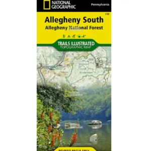
Planning your Allegheny South adventure? Grab National Geographic’s waterproof topographic map – your essential guide to northwestern Pennsylvania’s wild beauty. Expertly crafted with local land managers, this Trails Illustrated map unlocks Hickory Creek Wilderness, Cook Forest State Park, Elk State Park, and the scenic Tionesta Lake area. Navigate confidently with detailed shaded relief topography, clear park boundaries, and precise trail mileage for hiking, biking, snowmobiling (including the Allegheny Snowmobile Loop!), and cross-country skiing.
Explore diverse landscapes knowing critical details are at your fingertips: river mileage on the Clarion and Allegheny for paddlers, boat launches, campgrounds, fishing spots, and hazard notes for safe Clarion River boat navigation. Perfect for day-trippers seeking relaxation or serious adventurers tackling the North Country Trail section featured here.
Built tough for real backcountry use, every Trails Illustrated map uses “Backcountry Tough” waterproof, tear-resistant paper that withstands downpours and scrapes. A full UTM grid ensures seamless GPS navigation integration, while color-coded zones make identifying wilderness areas effortless. Whether you’re planning a family picnic near Clear Creek State Park or a multi-day trek through Allegheny Islands Wilderness, this durable map delivers reliable guidance through Pennsylvania’s most breathtaking terrain. Don’t just visit the forest—explore it deeply and safely.